
Adroit GIS
Unlocking the Power of Location: GIS for Smarter Decisions
Transforming data into geographic insights - visualise and monitor processes in real-time using advanced mapping technologies integrated with your SCADA environment.
Overview
Mapping the World, Empowering Decision-Makers
A geographic information system (GIS) is simply a way of displaying data related to specific positions on the Earth's surface to allow one to easily understand their patterns and relationships.
GIS relates to SCADA because a map overview is most often the starting point of navigation in geographically dispersed projects. The GIS add-on comprises three main components: a datasource storing items and hierarchy in the SmartUI server, a mapping control that displays items on maps with full navigation, and a coordinate agent managing location properties dynamically.
The integration of GIS and SCADA enables accurate asset tracking, environmental monitoring, and regulatory compliance - all from a single, unified platform.
Why Choose Us
Smart Features for Smart Infrastructure
Advanced GIS capabilities purpose-built for SCADA integration, asset tracking, and real-time geographic monitoring.
Third-Party GIS Engine Support
Supports third-party GIS mapping engines and coordinate systems, giving your team flexibility to work with the mapping formats best suited to your infrastructure and data sources.
Learn MoreCoordinate Management
Combine latitude and longitude values into a single unified value, and log both coordinates simultaneously for accurate, structured position data across your asset fleet.
Learn MoreReal-Time Alarm Tracking
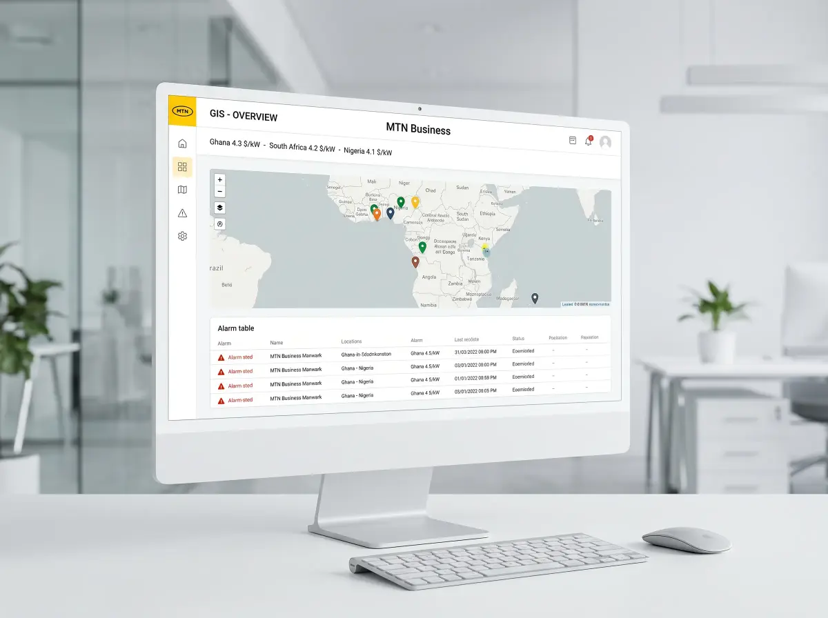
Real-time location tracking of alarms and events - with support for warning and alarm geofences that raise alerts automatically based on an asset's position relative to configured fence boundaries.
Learn MoreAdroit Smart UI Dashboards
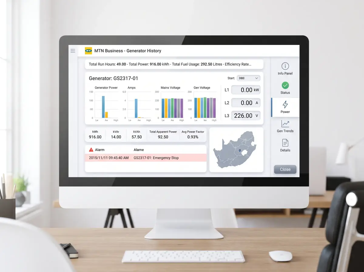
Integration with Adroit Smart UI for custom GIS dashboards - giving operators and engineers a real-time spatial view of assets, alarms, and process states.
Learn MoreIndustry-Ready GIS
Ideal for industries like utilities, mining, municipal services, and agriculture - leverage geographical data visualisation to analyse spatial patterns and trends across your operation.
Learn MoreBuilt for Adroit Version 10+
Built for Adroit Software Version 10 and above - integrate GIS with SCADA to support environmental monitoring and regulatory compliance with accurate location records and spatial audit trails.
Learn More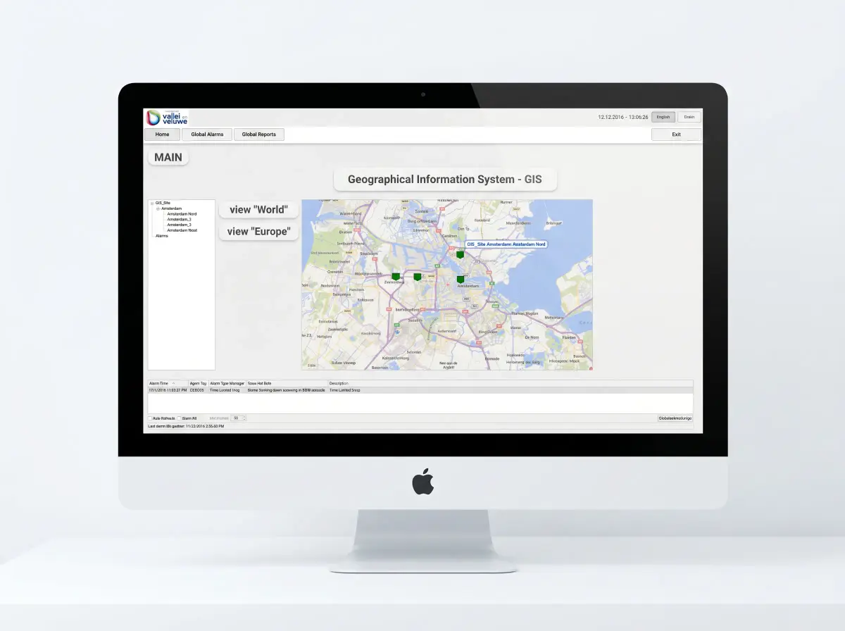
Mapping Control
Enhance SCADA with GIS: Real-Time Visual Intelligence
The Adroit GIS mapping control displays your assets on live maps with full navigation - panning, zooming, and drilling into specific areas of your operation. Each mapped item reflects its live SCADA status, giving operators an immediate spatial awareness of plant conditions.
Remote monitoring capabilities enhance organisational flexibility, enabling teams to track geographically dispersed assets from a single control interface.
SCADA Integration
Seamless Integration with Mitsubishi Hardware
The coordinate agent manages location properties dynamically, updating asset positions in real-time as your SCADA system receives data. This tight integration ensures your geographic view is always in sync with your process data.
The datasource component stores items and hierarchy in the SmartUI server - making GIS data available across your entire Adroit environment without requiring separate infrastructure or additional licensing overhead.
GIS Documents
Questions often asked.
The system comprises the GIS datasource, the GIS Mapping Control, and the Coordinate Agent. These work together to store items, display them on maps, and manage location properties dynamically.
Utilities, transportation, and emergency services gain particular advantages where real-time data can prove critical for operational decisions.
The visual representation facilitates asset tracking, environmental monitoring, regulatory compliance, and enables remote monitoring for tracking assets from any location.
The ability to overlay various data layers on maps supports informed decision-making and reveals geographical patterns that enable proactive management strategies.